Datasets
RoadAnomaly21
Anomaly track: general anomaly segmentation in full street scenes
- 100 test images with pixel-level annotations of resolution 2048x1024 and 1280x720
- 10 extra images published with pixel-level annotations
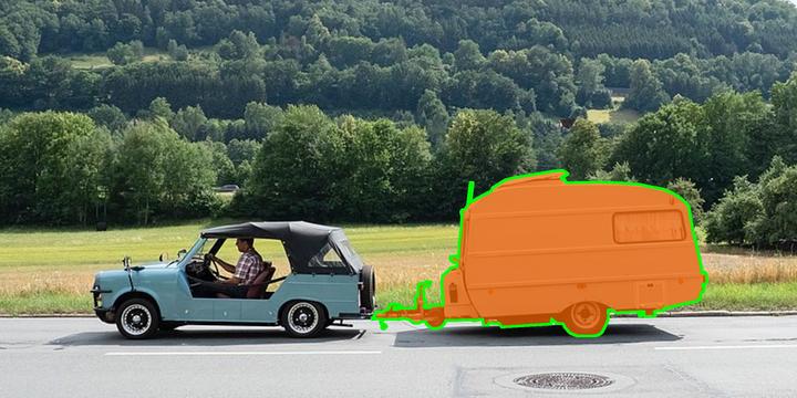
- at least one anomalous object per image, e.g. animals and unknown vehicles
- anomalies can appear anywhere in the image
- anomalies widely differ in size (from 0.5% to 40% of the image)
- images were collected from web resources and therefore depict a wide variety of environments
RoadObstacle21
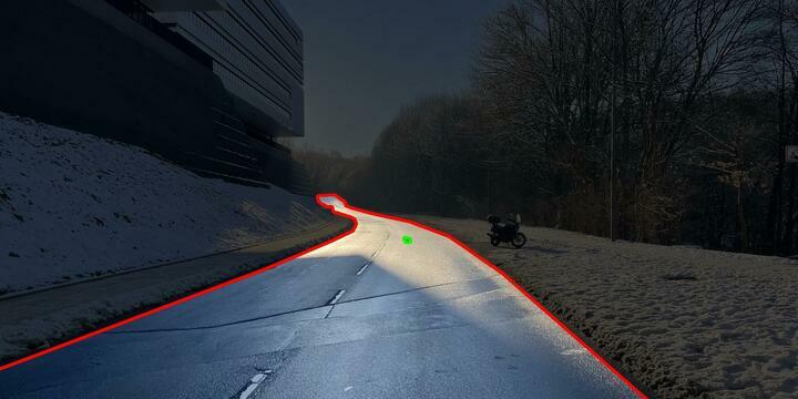
Obstacle track: obstacle segmentation with the road as region of interest
- 327 test images with pixel-level annotations of resolution 1920x1080
- 30 extra images published with pixel-level annotations
- the obstacles in this dataset can be understood as anomaly objects as well
- object types: e.g. stuffed toys, sleighs, tree stumps, ...
- obstacles appear at different distances (one distance per image)
- different road surfaces, lighting and weather conditions available
Labeling policy
The pixel-level annotations of both datasets include three classes:
- anomaly / obstacle
- not anomaly / not obstacle
- void
The 19 evaluation classes from Cityscapes serve as basis to judge whether an object is anomalous or not. We assign image regions to the void class if they cannot be assigned to any of the Cityscapes classes and also do not belong to the objects / regions of interest, i.e. they are neither anomaly nor obstacle.
Anomaly example

Figure 1: The anomalous object, in this example the caravan, is highlighted in orange and additionally with green contours. The anomalous objects are allowed to appear anywhere in the image.
Obstacle example

Figure 2: The obstacle, in this example a stuffed toy, is highlighted with green contours. The region of interest is given by the road (red contours), darkened regions are excluded from the evaluation.